
Land Survey Equipment list
 Surveying equipment has advanced in technical complexity over the years.
Images
The process of surveying land uses a series of precision instruments to measure features such as distance, area and elevation. All of these measurements are important to determine what a parcel of land is useful for and how best to go about using it. From real estate developers to land investors, surveying tools are an essential part of verifying and analyzing land.
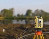
Levels
Some of the most important surveying tools are levels. Surveyors use levels with sighting tubes or lasers to measure the angle of a fixed point on a rod positioned elsewhere on the property relative to the position of the level. Taking measurements with a level at regular intervals gives a rough outline of the land's topography. Levels for surveying include automatic levels, which require less effort on the part of the surveyor, and basic hand levels, which are easy to use but only provide rough distance and elevation estimates for preliminary work.
Tripods
Surveying levels are typically attached to tripods, which keep them steady for precise measuring. Surveying tripods also feature height gauges, which indicate the height of the level above the ground when the tripod is set up in various positions. Some surveyors use bipods, which feature two legs instead of three, or single-legged monopods, for supporting levels in areas where there isn't room to set up a freestanding tripod.
Hand Tools
Not all surveying tools are high-tech gear. Basic hand tools, including ropes, measuring tapes, axes, saws, picks and brightly colored tape are all essential for a proper land survey. Tools such as axes and saws are useful for cutting away plants and branches that prevent clear sight lines between levels and rods. Surveyors use tape to mark the sites from which they take measurements, making it easier to cover a parcel of land methodically and come back later for more measurements.
Charts and Tables
Surveying is only useful when the surveyor keeps detailed and accurate records. Surveying charts include site outlines and maps that surveyors use to record data and express it visually for clients. Blank table templates provide boxes for surveyors to record measurement data as they work. While this type of equipment is much simpler than other surveying tools, it is no less essential to the process and should be part of any surveying checklist.
Share this article
Related Posts

Latest Posts


